Spacecraft operating On-orbit
Mars Odyssey
Launched: April 7, 2001
Mars Orbit Insertion: October 24, 2001
Mars Odyssey holds the record for the longest continually active spacecraft in orbit around a planet other than Earth, over two decades! The spacecraft's mission is to investigate the Martian environment and to provide information on hazards that future explorers might face.
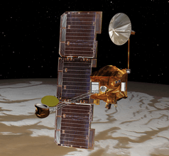
Mars Odyssey has mapped Mars, providing data on surface composition and the radiation environment. It discovered large amounts of water ice below the surface around the poles and provided a communication relay for the two Mars Exploration Rovers - - Spirit and Opportunity.
Instruments
Thermal Emission Imaging System (THEMIS)
The THEMIS camera provides visible and infrared imaging to characterize how minerals are distributed on the surface of Mars with a special emphasis on those that can only form in the presence of water.
Gamma Ray Spectrometer (GRS)
The gamma-ray spectrometer searches for elements on or near the Martian surface. It can detect the presence of 20 chemical elements, including hydrogen carbon, silicon, iron and magnesium.
Mars Radiation Environment Experiment (MARIE)
This instrument studied the radiation environment on the way to Mars and in the Martian atmosphere. Unfortunately, the instrument failed in 2003.
Mars Express
Launched: June 2, 2003
Mars Orbit Insertion: December 25, 2003
Mars Express orbiter was launched by the European Space Agency (ESA)). It carries seven instruments to study Mars, mapping surface terrain, composition and study the subsurface and atmosphere. Since 2004, Mars Express orbiter has been very successful returning high-resolution images and mapping the mineralogy on Mars surface. It has examined the subsurface permafrost and the atmosphere of the red planet.
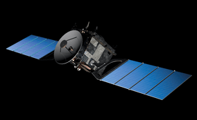
Mars Express was sent to Mars with a rover, named Beagle 2. Beagle 2 was to land on Isidis Planitia, a large flat sedimentary basin on Mars, but Earth-based mission controllers could not contact the lander after 7-min of terror. Orbiters at Mars made a search for signals but the mission was declared lost. The remains of the lander were spotted by Mars Reconnaissance Orbiter in 2013.
Instruments
Surface/subsurface Instruments
HRSC (High Resolution Stereo Camera)
The HRSC camera unit has a HRSC stereo color scanner and the Super-Resolution Channel (SRC). The camera produces color images with up to 2 m resolution. It also provides stereoscopic and 3d views of Mars surface.
Visible and Infrared Mineralogical Mapping Spectrometer (OMEGA)
OMEGA maps the surface mineral composition in the visible and infrared light wavelength as reflected from the planet's surface. OMEGA also measures the atmospheric composition.
Sub-surface Sounding Radar Altimeter (MARSIS)
MARSIS is a subsurface radar sounder with a 40-meter (130-foot) antenna, looking for water below the surface of Mars.
Atmosphere and Plasma Instruments
Planetary Fourier Spectrometer (PFS)
PFS is an infrared spectrometer optimized for atmospheric studies and covering the wavelength range 1.2 to 45 µm in two channels. The shorter wavelength channel gets to a spatial resolution of ten kilometers while the longer wavelength channel and has a resolution of 20 kilometers.
Ultraviolet and Infrared Atmospheric Spectrometer (SPICAM)
SPICAM is an imaging spectrometer equipped with two channels, one for ultraviolet wavelengths and one for infrared.
Energetic Neutral Atoms Analyser (ASPERA)
ASPERA studies the solar wind interaction with the Mars atmosphere in near-Mars space using energetic neutral atom (ENA) imaging and measurements of charged-particles.
Mars Radio Science Experiment (MaRS)
MaRS uses radio signals to investigate atmosphere, surface, subsurface, gravity and solar corona density during Mars solar conjunctions.
Visual Monitoring Camera (VMC)
VMS a small camera that was used to monitor the lander deployment.
Mars Reconnaissance Orbiter
Launched: August 12, 2005
Mars Orbit Insertion: March 10, 2006
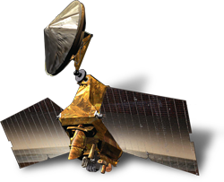
Mars Reconnaissance Orbiter or MRO is an orbiting spacecraft that is designed to study the geology and climate of Mars, carry out reconnaissance for possible future landing sites, and act as a data relay from surface missions back to Earth.
Instruments
High Resolution Imaging Science Experiment (HiRISE)
HiRISE is a reflecting telescope 20 inches in diameter (.5 m). At launch it was the largest ever carried on a deep space mission.
Compact Reconnaissance Imaging Spectrometer for Mars (CRISM)
CRISM is a visible and near infrared (VNIR) spectrometer that produced detailed maps of the surface mineralogy of Mars.
Context Camera (CTX)
CTX takes grayscale images that can cover 30 km (18.6 mi.) of terrain in a large swath, up to 160 km.
Mars Color Imager (MARCI)
MARCI is a wide-angle, low-resolution camera that views the surface of Mars in five visible and two ultraviolet bands.
Mars Climate Sounder (MCS)
MCS is a spectrometer that operates in the visible and infrared regions of the spectrum.
Shallow Subsurface Radar (SHARAD)
SHARAD probes the subsurface using radar waves from 15- to 25-megahertz. It is used to study the Martian polar ice caps and underground layers of ice, rock, or water. SHARAD is designed to operate with Mars Express's MARSIS.
- Find out more at Astra's about Mars Reconnaissance Orbiter
Mars Atmosphere and Volatile Evolution (MAVEN)
Launched: November 18, 2013
Mars Orbit Insertion: September 22, 2014
MAVEN's primary mission was to explore Mars' upper atmosphere, ionosphere and how the atmosphere interacts with the Sun and solar wind. MAVEN's data can help to determine how the loss of volatiles from Mars' atmosphere into space has occurred through time. This should give scientists insight into the history of Mars' atmosphere and climate, liquid water, and planetary habitability.
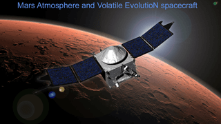
Less than a month after the MAVEN orbiter went into orbit around Mars, on October 19, 2014, comet "Siding Spring" (C/2013 A1) hurtled past Mars at about 125,000 mph (56 km per second). The comet came within about 87,000 miles (139,500 kilometers) of Mars. Because of this mission operators moved the spacecraft into a safer orbit to avoid high-energy dust particles. While the comet passed, MAVEN and five other spacecraft (Mars Reconnaissance Orbiter, Hubble Space Telescope, Mars Express, Mars Odyssey, Mars Orbiter Mission) also took detailed information on the Siding Spring comet, making its first visit to the inner solar system from the Oort cloud.
MAVEN carried 3 suites of Instruments
Particles and Fields Package
The Particles and Fields Package, built by the University of California at Berkeley - Space Sciences Laboratory with support from the University of Colorado Boulder - Laboratory for Atmospheric and Space Physics and Goddard Space Flight Center , contains six instruments to characterize the solar wind and the ionosphere of Mars.Solar Wind Electron Analyzer (SWEA)
SWEA measures the solar wind and ionospheric electrons.
Solar Wind Ion Analyzer (SWIA)
SWIA measures the solar wind and magnetosheath proton flow around Mars and constrains the nature of solar wind interactions with the upper atmosphere.
Suprathermal and Thermal Ion Composition (STATIC)
STATIC measures thermal ions to reveal how ions are escaping Mars today.
Solar Energetic Particle (SEP)
SEP measures the impact of the solar wind on the upper atmosphere of Mars.
Magnetometer (MAG)
MAG measures interplanetary solar wind and ionospheric magnetic fields.
Langmuir Probe and Waves (LPW)
LPW measures ionospheric properties, studying wave heating of the upper atmosphere, and solar extreme ultraviolet (EUV) energy hitting the atmosphere.
Extreme Ultraviolet (EUV) Monitor
Part of the Langmuir Probe and Waves Monitor, the EUV Measures solar emissions from different regions of the Sun in three distinct EUV bands
Neutral Gas and Ion Mass Spectrometer (NGIMS)
NGIMS measures the composition and isotopes of thermal neutrals and ions.
The Remote Sensing Package
The Remote Sensing Package, developed at the Laboratory for Atmospheric and Space Physics (LASP). It consists of the Imaging UltraViolet Spectrograph (IUVS) and the Remote Sensing Data Processing Unit. The Remote Sensing Data Processing Unit uses the spectrograph's main electronics box to control the spectrograph and communicate with the spacecraft. It is used to study global characteristics of the upper atmosphere and ionosphere using ultraviolet sensors.
Radio Occultation Science Experiment (ROSE)
ROSE is designed to use two-way X-band radio occultations through the martian ionosphere to study its properties. ROSE uses two-way, single frequency radio transmission and reception when the spacecraft, Mars, and Earth are aligned so that the radio waves will pass through the ionosphere.
Mars Orbiter Mission (ISRO)
Launched: November 5,2013
Mars Orbit Insertion: September 24, 2014
The Mars Orbiter Mission is the Indian Space Research Organisation (ISRO) first attempt at an interplanetary mission. The name of the orbiter is, "Mangalyaan" , it means Mars-craft in Hindi with mangala meaning, "Mars" and yāna meaning, "craft" or vehicle. Mangalyaan's success at Mars makes India the first Asian country to successfully orbit Mars. It has been sending back valuable data for 9 years.
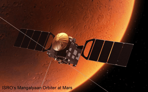
Because this was the first interplanetary craft that Indian Space Research Organisation (ISRO) attempted to build, Mangalyaan's main objectives were to develop the technologies required for design, planning, management and operations of an interplanetary mission. While at Mars, Mangalyaan would explore Mars' surface features, morphology, mineralogy and the Martian atmosphere. It was launched on India's own Polar Satellite Launch Vehicle (PSLV-C25).
In October 2022, ISRO lost communications with the orbiter and has declared its mission complete.
Instruments
Mars Color Camera (MCC)
MCC provides images and information about the surface features and composition of Martian surface.
Thermal Infrared Imaging Spectrometer (TIS)
TIS mapped the surface composition and mineralogy of Mars.
Methane Sensor for Mars (MSM)
TMSM is designed to measure Methane (CH4) in the Martian atmosphere.
Mars Exospheric Neutral Composition Analyser (MENCA)
MENCA studies the composition of Martian upper Atmosphere.
Lyman Alpha Photometer (LAP)
LAP measures the relative abundance of deuterium and hydrogen to better understand the process of the loss of water from the planet.
ExoMars Trace Gas Orbiter
Launched: March 14, 2016
Mars Orbit Insertion: October 19, 2016
Trace Gas Orbiter (TGO) is part of the ExoMars mission. The TGO spacecraft carried the Entry, Descent and landing demonstrator Module (EDM), called Schiaparelli , from Earth to Mars. Unfortunately the lander crashed on Mars on October 19, 2016 when its parachute was deployed too early. The second phase of TGO includes a lander and a rover. This mission was a joint mission between Roscosmos and ESA.

The Trace Gas Orbiter mission is to monitor seasonal changes in Mars' atmospheric composition and temperature. Its instruments have mapped subsurface hydrogen to a depth of a meter, searching for deposits of water-ice below the surface. Knowing the locations where trace gases can be found will help choose landing sites for future missions. TGO was also intended to be a communication relay for probes on the surface of Mars.
TGO's follow up mission EXOMARS was scheduled to launch for the 2022-23 opposition of Mars, the mission has met with a setback due to the Russian attack on the Ukraine. It is unknown when or if the ExoMars mission will continue. Details on the future ExoMars Rover mission at Astra's.
Instruments
Nadir and Occultation for Mars Discovery (NOMAD)
NOMAD camera provides visible and infrared imaging to characterize how minerals are distributed on the surface of Mars with a special emphasis on those that can only form in the presence of water.
Atmospheric Chemistry Suite (ACS)
ACS has three infrared spectrometers to investigate the chemistry, aerosols, and structure of the atmosphere. It is part of the Russian contribution to the ExoMars ESA-Roscosmos mission.
Colour and Stereo Surface Imaging System (CaSSIS)
CaSSIS is a color stereo camera with high-resolution (4.5 m per pixel (15 ft/pixel). It will help find candidate landing site locations for future missions. The imager can cover an eight km swath of Mars surface at four different wavelengths. Developed by Switzerland.
Fine-Resolution Epithermal Neutron Detector (FREND)
FREND is a neutron detector searching for hydrogen, in water or hydrated minerals, in the top 1 m of Mars' surface. Developed by Russia.
UAE Al-Amal or Hope
Launched: July 19, 2020
Mars Orbit Insertion: February 9, 2021
Al-Amal is the United Arab Emirates (UAE) Mars Mission. UAE plans to study and colonize the red planet.
Instruments
Emirates eXploration Imager (EXI)
EXI is a high-resolution camera to study the Martian atmosphere in the visible and ultraviolet spectrums.
Emirates Mars Ultraviolet Spectrometer (EMUS)
EMUS is a far-ultraviolet imaging spectrograph to study seasonal changes of carbon monoxide and oxygen in Mars' atmosphere.
Emirates Mars InfraRed Spectrometer (EMIRS)
EMIRS is an advanced I/R spectrometer that examines temperature profiles, ice, water vapor and dust in the atmosphere. It will study the lower and middle atmosphere.
- Find out more at Astra's about the Al-Amal Mission
Tianwen 1 orbiter
Launched: July 23, 2020
Mars Orbit Insertion: February 10, 2021
Tianwen 1 is the first mission to Mars ever attempted by the China National Space Administration (CNSA). The Tianwen 1 mission included an orbiter, a lander , and a rover. Tianwen means "questions to heaven" or "quest for heavenly truth", from a classical poem written by Qu Yuan, an ancient Chinese poet.
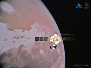
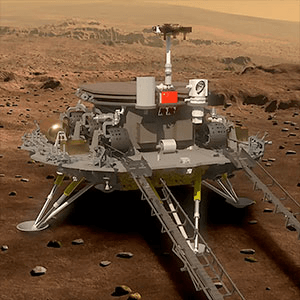
In addition to the orbiter, Tianwen deployed a lander and a rover to the surface of Mars. The lander carried an emergency locator beacon that could withstand crashing on the surface. The Tianwen orbiter helps maintain communication between the rover and the Earth. The rover, named Zhurong after the god of war, landed on Utopia Planitia and is operating on the surface.
Instruments
Medium-Resolution Camera (MoRC)
MoRC has a resolution of 100 m from a 400-km orbit
High-Resolution Camera (HiRIC)
HiRIC has a resolution of 2.5 m from a 256-km orbit
Mars Ion and Neutral Particle Analyzer (MINPA)
MINPA measures the ions in space environment examining their physical parameters such as the density, velocity and temperature.
Mars Mineralogy Spectrometer (MMS)
MMS spectrometer uses visible light and infrared to analyze the Martian surface composition. It will also investigate the regolith and subsurface structure of Mars.
Mars Orbiter Magnetometer (MOMAG)
Used to map Mars' magnetic field.
Mars Energetic Particle Analyzer (MEPA)
MEPA analyzes the energy spectrum, flux and elemental composition of particles and ions.
Mars Orbiter Scientific Investigation Radar (MOSIR)
MOSIR explores the Martian surface and subsurface water-ice using radar.
Mission Complete
Mars Global Surveyor
Launched: November 7, 1996
Mars Orbit Insertion: September 1997
Mission Complete: November 2006
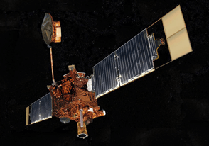
Mars Global Surveyor orbited Mars from 1997 to 2006, it was built as a replacement for the Mars Observer that failed to reach Mars insertion orbit in 1993. Mars Global Surveyor's orbit was nearly circular and nearly polar, Because of the long duration of its mission, it was able to observe ongoing surface processes. Its Mars Orbiter Camera (MOC) provided high-resolution images as well as low-resolution global views. The spacecraft produced a planet-wide topographic map and discovered evidence of an early magnetic field. The orbiter lasted 4.8 Martian years.
Instruments
Mars Orbital Camera (MOC)
MOC used 3 instruments: a narrow angle camera that took high resolution images in black and white(usually 1.5 to 12 m per pixel) and red and blue wide-angle pictures (240 m per pixel) and daily global imaging (7.5 km per pixel). MOC returned more than 250,000 images during its lifetime.
Mars Orbital Laser Altimeter (MOLA)
This instrument measured the height of Martian surface features. A laser fired pulses of infrared light 10 times each second, striking a 160-meter (525-foot) area on the surface. By measuring the length of time it took the light to return to the spacecraft determined the distance to the planet's surface. Data from this instrument enabled scientists to build a detailed topographic map of the Martian landscape.
Thermal Emission Spectrometer (TES)
TES measured the thermal infrared energy, or heat, emitted from Mars using thermal emission spectroscopy. This instrument mapped the mineral composition of the surface and gathered data on the geology and atmosphere of Mars.
Magnetometer/Electron Reflectometer (MAG/ER)
MAG/ER's magnetometer and electron reflectometer was used to study the planet's magnetic fields and determined that Mars does not have a global magnetic field but rather many smaller localized fields.
Radio Science Experiment (RS)
The RS experiment used data provided by the spacecraft's telecommunications system, high-gain antenna, and the ultra-stable oscillator acting as a very precise clock, to map variations in the gravity field by tracking where the spacecraft speeds up and slows down as it orbits Mars. A precise map of the gravity field of Mars was constructed. RS also studied how radio waves are distorted as they pass through Mars' atmosphere in order to measure the atmosphere's temperature and pressure.
Mars Relay Antenna (MR)
The Mars Relay antenna was built by the French space agency, Centre National d'Etudes Spatiales CNES. It was used to support the Mars Exploration Rovers, Spirit and Opportunity to relay data back to Earth.
Mars Viking
Viking 1 launch: August 20, 1975
Viking 2 launch: September 9, 1975
Viking 1 and Viking 2 orbiters were sent to Mars with a lander. They were both very successful, orbiting Mars and returning images. The mission of the orbiters was to transport the landers to Mars, locate landing sites, act as communication relay for the landers, and carry out scientific investigations. More than 57,000 images were received from the Viking orbiters.
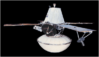
Originally, the first Viking spacecraft experienced some problems while on the launchpad causing its batteries to discharge so the second Viking spacecraft was rolled out and launched first. It was renamed Viking 1 and the rest is history. Viking 1 was inserted into Mars orbit on June 19, 1976 with its counterpart lander reaching the martian surface in Chryse Planitia on July 20, 1976. Because of its orbit, Viking 1 was able to take fantastic images of the martian volcanoes in the Tharsis reagion of Mars. Viking 1 was also used to take the first clear images of the martian moon, Phobos, passing as close as 80 km. The orbiter ran out of altitude-control gas and may have impacted on the surface.
Viking 2 orbiter was inserted into Mars orbit on August 7, 1976 with its counterpart lander reaching the martian surface on September 3, 1976. The Viking 2 lander touched down in Utopia Planitia. The orbiter developed a leak in its propulsion system. It worked until July 25, 1978, cruising 706 orbits around Mars and returning ~16,000 images.
Instruments
Infrared Thermal Mapper (IRTM)
The IRTM instrument was used to study Mars' atmosphere in IR bands from 6 μm to 30 μm. It used four Cassegrain telescopes to measured the temperatures of the atmosphere and the surface of Mars. In addition to other investigations, IRTM measured the albedo of Mars. Albedo is the amount of sunlight reflected back into space rather than being absorbed by the planet. In this case it was the surface of Mars, rather than the atmosphere that was measured.
Mars Atmospheric Water Detector (MAWD)
MAWD measured solar infrared radiation reflected from the surface through the atmosphere studying water-vapor absorption lines in the 1.4-micrometer band.
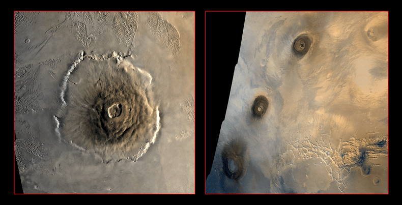
Viking 1’s orbit enabled it to send back sharp images of the volcanoes on the Tharsis Bulge, including the solar system’s bohemoth Olympus Mons and three other large voicanoes (from top to bottom) Ascraeus Mons, Pavonis Mons, and Arsia Mons. - - Images courtesy NASA
- - Find out more about Mars Viking on Astra's Mars Exploration Page
Navigate Astra's Guide to Mars Exploration:
3 Faces of Mars Home | Mars Orbital Explorers | Mars 2020 | Mars Rovers | Curiosity Rover | Perseverance Rover
This webpage is ©2023 D. E. Jenkins all rights reserved. Please use the contact page to get permission to use this content or to send comments or corrections.
